Where’s the Flood?: Real-time flood risk visualization via server-based MR enhances accessibility and public safety
A research group at Osaka University developed a mixed reality (MR) system to intuitively share flooding forecasts. This system can be visualized on a mobile device's web browser through Internet communication and server rendering. It allows wider populations to view dynamic flood forecasts and can increase risk preparedness.
Climate change is increasing flood risks in urban areas, with heavy rainfall disasters now becoming a global problem. Numerical simulations predict flooding from heavy rain and river overflows, usually displaying results on flat maps. However, map scale can limit detailed risk assessment, making it difficult for residents to fully understand flood risks. Now, researchers from Osaka University have developed a mobile mixed reality (MR) system as a powerful tool for real-time flood risk visualization through server-based rendering and web-based access. This allows urban populations to view dynamic flood forecasts on their mobile devices, enhancing community preparedness and response.
By offloading the computational workload to a server, MR displays can be rendered efficiently, allowing real-time visualization on commonly-used mobile devices such as smartphones.
Access to these MR displays is streamlined through web browsers, eliminating the need for specialized applications. This accessibility means that multiple devices can connect simultaneously, enabling widespread participation in MR visualizations. The system intelligently assigns the optimal server from a pool of rendering servers, ensuring efficient performance and scalability. This approach democratizes access to advanced flood forecasting tools, making it feasible for many users to engage with MR visualizations without the constraints of dedicated software.
"As climate change heightens flood risks, mitigating these risks is crucial," says lead author of the study Ryoma Tsujimoto. "We expect that our study will help people to intuitively understand flooding risks, regardless of their expertise, and that eventually, social implementation of these research results will improve people's safety and promote and industrialize DX (Digital Transformation) in the built environment field."
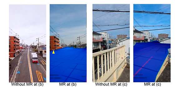
Fig. 1
Examples of MR images displayed on a smartphone. (a) is a viewpoint from below the flooded surface; (b) and (c) are from above the flooded surface, looking down from a pedestrian bridge.
Credit: 🄫2024 Ryoma Tsujimoto et al., Environmental Modelling & Software
Fig. 2
Overview of the proposed system. The upper part shows the preliminary preparation procedure, and the lower part shows the actual MR display flow.
Credit: 🄫2024 Ryoma Tsujimoto et al.
Fig. 3
Example of a 3D urban flood model. This model reproduces flooding within an area of 2 km from north to south and 2.5 km from east to west. Not only the depth of flooding, but also the velocity of the floodwaters can be represented by color changes.
Credit: 🄫2024 Ryoma Tsujimoto et al., Environmental Modelling & Software
The article, “Server-enabled mixed reality for flood risk communication: On-site visualization with digital twins and multi-client support,” was published in Environmental Modelling & Software at DOI: https://doi.org/10.1016/j.envsoft.2024.106054.
Previous Research Articles
- Images of simulated cities help artificial intelligence to understand real streetscapes (9/21/2023)
- City digital twins help train deep learning models to separate building facades (9/6/2022)
- Streaming from the future (7/29/2022)
- X-ray street vision (9/7/2021)
- Paint the town (9/6/2021)
- Eye in the sky (8/20/2021)
- Mixed reality gets a machine learning upgrade (3/24/2021)
- Virtual demolition (6/17/2020)
Related Links
Associate Professor FUKUDA Tomohiro (Researcher Directory)
EurekAlert!
Asia Research News